

Short answer
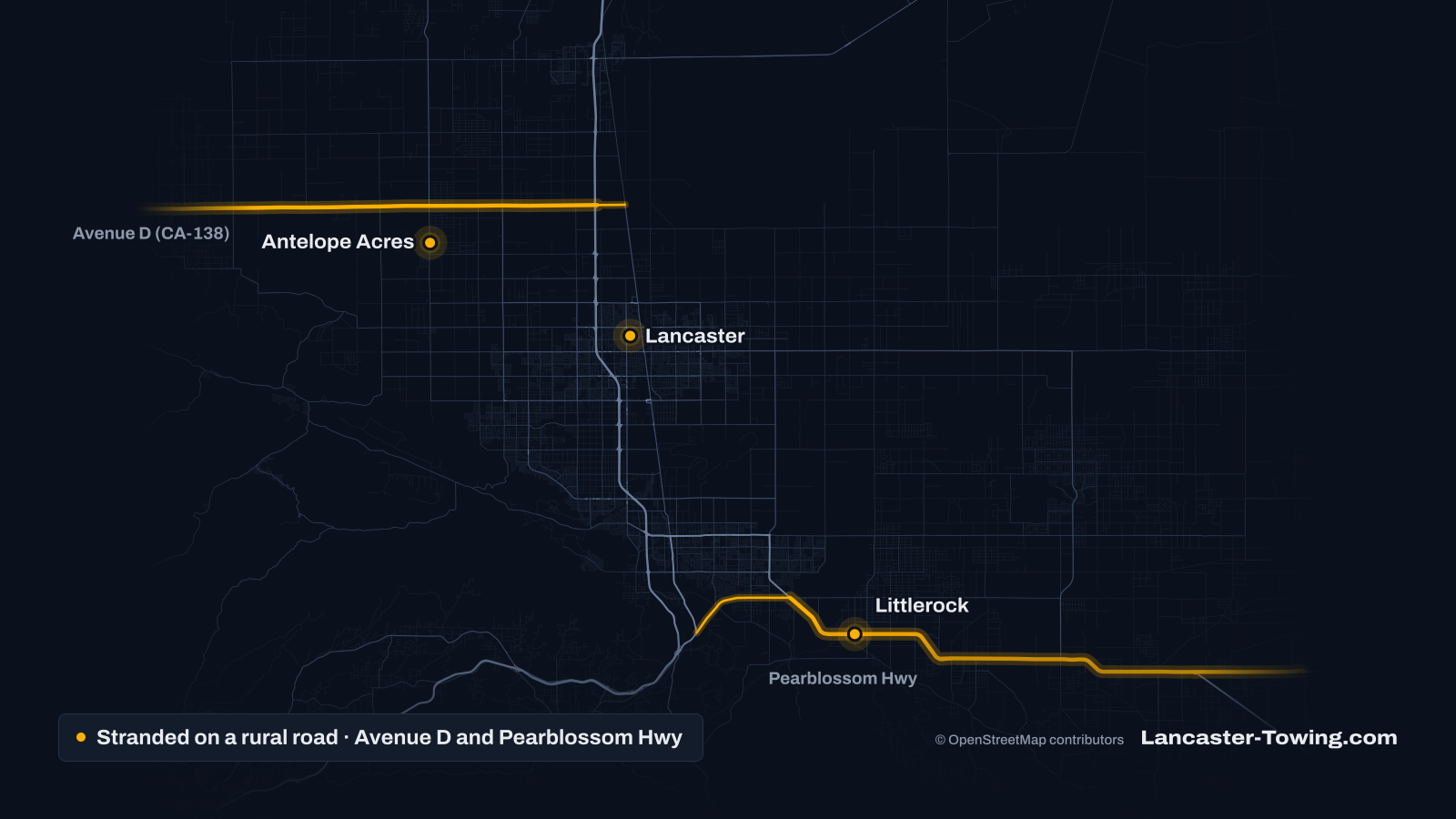
If you break down on SR-138 (Avenue D or Pearblossom Highway) or a desert back road in the Antelope Valley, get fully off the pavement onto firm ground, turn on your hazards and save your exact location while your phone has signal: the nearest cross street or your GPS coordinates. Call 911 for any emergency. Stay with the car unless help is close, and never leave children or pets inside in the heat.
What is different about breaking down out here?
Three things: distance, exposure and finding you.
- Distance. By road, Gorman is about 47 miles from Lancaster City Hall, and Littlerock is about 20 to 24 miles (route estimates from OpenStreetMap data). A tow truck may have a long drive to reach you, and you may be waiting in the open.
- Exposure. Summer heat, spring wind and cold winter nights all matter more when there is no building nearby.
- Finding you. Many places have no street address, and two-lane roads look alike for miles. A precise location is the most useful thing you can give.
Don’t expect a call box either. When Metro’s board cut LA County’s call boxes in 2019, it kept them only on a few rural roads with poor cell service, such as Angeles Forest Highway and Lake Hughes Road (board report). SR-138 was not on the list.
The roads, and what to expect on each
SR-138 west: Avenue D toward Gorman
You join it from CA-14 at exit 49, SR-138 West / Avenue D (Caltrans exit list). According to route data, Avenue D is a two-lane road that runs straight for about 22 miles before the highway becomes Lancaster Road and heads on toward Gorman and I-5.
A plan to widen this corridor exists, but the federal permitting dashboard lists its environmental review as paused. Expect the road as it is today.
The Antelope Acres area sits off this stretch. In spring, the Poppy Reserve on Lancaster Road draws crowds, and State Parks warns of drivers stopping suddenly, opening doors and people walking on the road there. It also says spring is normally very windy.
SR-138 east: Pearblossom Highway
You join it from CA-14 at exit 35, SR-138 East / Palmdale Blvd. The route follows Palmdale Boulevard east, then 47th Street East and Fort Tejon Road. At Avenue T it becomes Pearblossom Highway, a largely two-lane road through Littlerock, Pearblossom and Llano.
Expect big rigs. Caltrans is studying a roundabout at SR-138 and 106th Street East, between Littlerock and Pearblossom, citing a history of angle collisions and heavy truck traffic between I-5 and inland destinations such as Victorville and Barstow (Caltrans project page). The project is still in its early study phase.
County roads and dirt roads
Off the highways, OpenStreetMap’s road data tags many roads around Lake Los Angeles, Littlerock and Antelope Acres as unpaved. Soft sand can grab a tire on a shoulder or a dirt road. If you are stuck, stop spinning the wheels: it digs you in deeper. Pulling the car back to firm ground is a winch-out. Mention it when you call so the right equipment comes.
What should you do first?
- Get fully off the pavement, onto ground that looks firm. Avoid stopping just over a rise or in a curve, where drivers can’t see you, and stay out of tall dry grass.
- Turn on your hazard lights.
- Save your location now, before you do anything else (see the next section).
- Call 911 if anyone is hurt, the car is on fire, or it is stopped in a lane.
- Call for the help you need. Out of gas: fuel delivery. Stuck in sand: a winch-out. Headed somewhere far away, such as back over to Santa Clarita: long-distance towing.
- Tell someone where you are. Text a friend your location and your plan.
On a two-lane road, traffic passes close. If you get out, stand well off the road on the side away from traffic.
How do you give your location with no address?
Use the grid. Name the highway and the nearest cross street, with East or West: “Avenue D at 110th Street West” or “Pearblossom Highway near 106th Street East.” 10th Street East and 10th Street West are different roads, so always say which.
Add a landmark if you passed one, such as the Poppy Reserve entrance on Lancaster Road or Saddleback Butte State Park on 170th Street East between Avenue J and Avenue K (State Parks).
Read your GPS coordinates. In most phone map apps:
- Tap the blue dot that shows where you are, or press and hold on that spot to drop a pin.
- The coordinates appear in the search bar or in the pin’s details: two numbers, latitude then longitude.
- In the Antelope Valley the first number starts with 34 and the second is negative, near -118. Read the minus sign out loud.
- Take a screenshot so you still have them if the signal drops.
The request form has an “Add my GPS location” button that attaches your coordinates to the request. Add a cross street or landmark anyway.
Stranded on the 138 or a dirt road right now?
Call for towing help (661) 555-0123Heat, water and waiting
At Lancaster’s Fox Field, July and August average highs are about 98°F, with about 36 days a year at 100°F or more (NOAA 1991–2020 normals). The station’s highest reading in its digital record since 1974 is 115°F, reached in 2013 and again in 2024. State Parks gives Saddleback Butte a summer average of 95°F, occasionally 115°F.
- Keep water in the car for everyone, including pets, all year.
- Find shade on the side of the car away from traffic if it is cooler outside than in.
- Never leave a child or pet in a parked car. The National Weather Service notes that a parked car can go from a safe temperature to a dangerous one in a few minutes.
- If the engine overheated, see what to do when your car overheats.
Heat illness is a 911 call
If anyone feels faint, confused or very unwell in the heat, call 911. Don’t wait for the tow.
Wind and blowing dust
Spring is wind season in the Antelope Valley. NWS advisories here warn of gusts to around 50 mph and that blowing dust can cut visibility. A High Wind Warning in May 2026 called for gusts to 60 mph and difficult travel for high-profile vehicles.
If dust is so thick you can’t see, pull completely off the pavement and wait it out with your seat belt on. Don’t stop in the lane.
Cold nights and storms
Lancaster averages about 68 nights a year at or below freezing, most of them in December and January. State Parks says frost and sub-freezing temperatures are common at Saddleback Butte in winter, with occasional snow. From November to March, keep a jacket or blanket in the car.
Storms can close county roads. In February 2026, LA County Public Works closed Angeles Forest Highway between Aliso Canyon Road and Highway 2 ahead of a storm. Check county road closures and Caltrans QuickMap before a long drive in bad weather.
Should you stay with the car or walk for help?
Usually stay. A car is easier to spot than a person walking, it gives shade and shelter, and it keeps you near the address you gave the dispatcher.
Walk only if all of these are true:
- help is close and you know exactly where you are going
- the weather is mild, not midday summer heat or a cold night
- you can walk well off the road, facing traffic
- you have water and a charged phone
If you leave, put a note on the dashboard with your phone number, where you went and the time you left.
Who to call
- 911 for injuries, fire, a car in the lane or any emergency.
- CHP Antelope Valley Area for crashes and road problems on SR-138, SR-18 and about 1,400 miles of unincorporated roads (CHP).
- CHP Antelope Valley Area non-emergency line: (661) 743-6060.
- LA County Sheriff’s Palmdale Station, which serves Littlerock, Pearblossom, Llano and Leona Valley: (661) 272-2400.
- LA County Sheriff’s Lancaster Station, which serves Antelope Acres and Lake Los Angeles: (661) 948-8466.
- LA County Public Works, for washouts or debris on county roads: 1-800-675-4357.
Coverage is confirmed on the call
Not every towing provider can reach every remote spot. When you call, the provider confirms whether it can reach your location, the price and an arrival estimate before anyone is sent.
More questions
What should I do if my car breaks down on Pearblossom Highway?
Get fully off the pavement onto firm ground, turn on your hazards and note the nearest cross street, such as 106th Street East, or your GPS coordinates. Call 911 if anyone is hurt or the car is in the lane. The CHP Antelope Valley Area handles crashes and road problems on SR-138.
Should I walk for help if I'm stranded on a desert road near Lancaster?
Usually not. The car is easier to spot than a person, and it gives you shade and shelter. Walk only if help is close, you know exactly where you are going, the weather is mild and you can stay well off the road.
How do I find my GPS coordinates on my phone?
Open your map app and tap the blue dot that marks your position, or press and hold on that spot to drop a pin. The latitude and longitude appear in the search bar or the pin's details. In the Antelope Valley the first number starts with 34 and the second is negative, near -118.
Who patrols Avenue D and the other rural roads in the Antelope Valley?
The CHP Antelope Valley Area covers SR-138, SR-18 and about 1,400 miles of unincorporated roads. The LA County Sheriff's Lancaster and Palmdale stations handle law enforcement in the communities along them.
Can a tow truck get to my car on a dirt road?
Often, but very soft sand or a washed-out road can stop a truck. Tell the dispatcher what the surface is like and whether there is room to turn around. A car that is stuck may need a winch-out before it can be towed.
Sources and official resources
- CHP Antelope Valley Area (545)
- LA County Sheriff: Lancaster Station
- LA County Sheriff: Palmdale Station
- Caltrans: SR-14 exit numbers (sheet last updated 2018)
- Caltrans Engagement Portal: SR-138 and 106th Street East roundabout project
- Federal Permitting Dashboard: SR-138 Northwest Corridor Improvement (I-5 to SR-14)
- LA Metro board report 2019-0239: call box system restructuring
- California State Parks: Antelope Valley California Poppy Reserve
- California State Parks: Saddleback Butte State Park
- NOAA NCEI: 1991–2020 monthly normals, Lancaster Fox Field
- Regional Climate Centers ACIS: Lancaster Fox Field daily record
- National Weather Service: Heat safety for children and pets in vehicles
- NWS Los Angeles/Oxnard High Wind Warning, May 15, 2026 (IEM archive)
- NWS Los Angeles/Oxnard Wind Advisory, April 1, 2025 (IEM archive)
- LA County Public Works: road closures
- LA County Public Works: storm road closures, February 2026
- Caltrans QuickMap