

Need a tow in Leona Valley?
To request a tow in Leona Valley, call and name the road you're on (Elizabeth Lake Road, Godde Hill Road or Bouquet Canyon Road) plus the nearest cross street or driveway landmark. The request goes to a towing provider serving Leona Valley and Palmdale. If the vehicle is headed to a shop in Palmdale or Lancaster, ask for the full price and an arrival estimate first. If a storm has closed roads, say so.
Where Leona Valley is
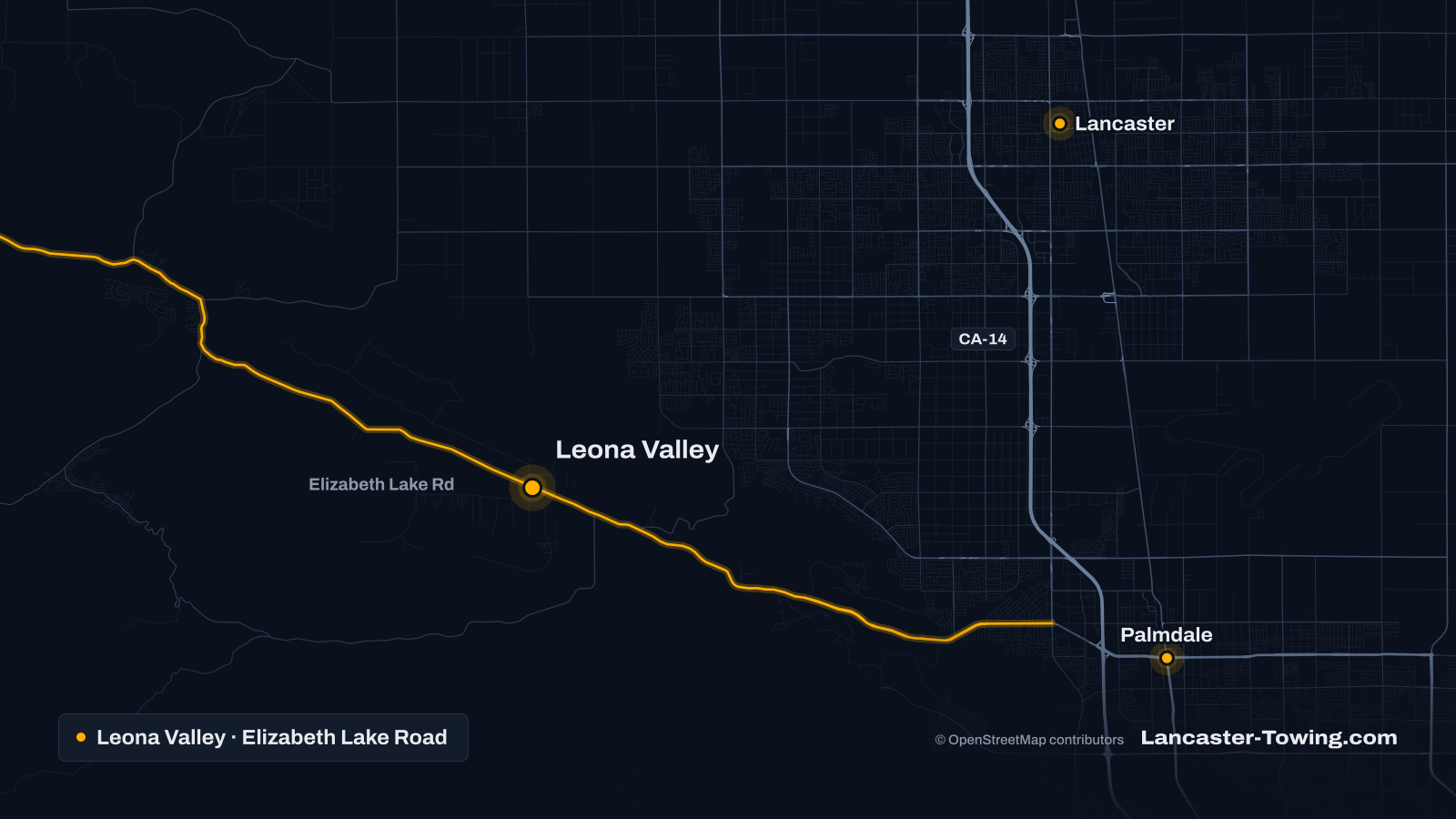
Leona Valley is a rural, unincorporated part of Los Angeles County, a long valley just west of Palmdale. The San Andreas Fault runs through it, and the US Geological Survey published a 1976 “Geologic map of the San Andreas fault zone, Leona Valley, California” for this stretch. The Census Bureau counts Leona Valley as a census-designated place of about 18.6 square miles.
From Lancaster, map routing goes south on 10th Street West, west on Avenue N, over Godde Hill Road and down to Elizabeth Lake Road. That is about 15 to 16 miles from Lancaster City Hall. From central Palmdale, road references describe Palmdale Boulevard continuing west as Elizabeth Lake Road, part of County Route N2.
The valley sits well above the Antelope Valley floor. USGS elevation data put points in the valley at roughly 3,100 to 3,500 feet, some 800 to 1,100 feet above Lancaster City Hall (about 2,343 feet). For forecasts, the Weather Service files the valley under a separate Western Antelope Valley Foothills zone.
The county’s Leona Valley Community Standards District, last updated in 2021, covers about 10,000 acres. Its map shows the City of Lancaster to the north, Palmdale to the east, the Angeles National Forest to the south, and the Elizabeth Lake and Lake Hughes district to the northwest.
Main roads in and around Leona Valley
- Elizabeth Lake Road. The valley’s main road, running northwest to southeast through the district. Southeast it leads into Palmdale; northwest it continues toward Elizabeth Lake and Lake Hughes.
- Godde Hill Road. The east-end link to Avenue N and 60th Street West, and the road map routing uses toward Lancaster.
- Bouquet Canyon Road. Leaves the south side of the valley and runs down the canyon toward its junction with Vasquez Canyon Road.
- Johnson Road and 110th Street West. Shown near the northwest edge of the district on the county map.
Common reasons drivers need a tow in Leona Valley
Storms, mud and closed roads. On October 15, 2015, the Sheriff’s Palmdale Station announced closures for heavy rain, flooding and mudslides: Elizabeth Lake Road at 25th Street West, Godde Hill Road at 60th Street West and Avenue N, and Bouquet Canyon Road at Vasquez Canyon Road. Those closures sat on the roads leading east toward Palmdale and Lancaster and south through Bouquet Canyon. When roads like these close, a car that slid into mud may have to wait, or the truck may need a longer way around.
Winter weather above the valley floor. In February 2026 the Weather Service put the Western Antelope Valley Foothills zone under a Winter Storm Warning calling for up to 4 inches of snow at 3,500 to 4,500 feet. Much of Leona Valley sits just under the bottom of that band, so check the forecast for your zone rather than Lancaster’s before a winter drive.
Unpaved roads and long driveways. OpenStreetMap, which is crowd-sourced and incomplete, tags roughly two in five mapped road miles in and near the valley as unpaved or track. On a rural parcel with a dirt driveway, a car that sinks into soft ground has to be pulled back to firm footing with a winch-out first.
A long tow to the shop. If your repair shop is in Palmdale or Lancaster, the tow has to leave the valley by Godde Hill Road or Elizabeth Lake Road first. Distance drives the price; see what a tow costs in Lancaster.
Stuck in Leona Valley? Call with your road and nearest cross street.
Call for towing help (661) 555-0123Towing and roadside services for Leona Valley
- A crash, or a car dead on a curve or in a lane: emergency towing. A crashed vehicle that ended up off the road calls for accident recovery.
- Into Palmdale or Lancaster for repairs: local towing.
- A dead battery, flat tire or empty tank at home or on the road: roadside assistance.
- Mud, sand or a soft driveway: a winch-out, then a flatbed if the vehicle can’t be driven.
If you stop on a curve, ask yourself whether drivers coming around the bend can see your car. If they can’t, get yourself well clear of the road while you wait.
Who to call besides a tow truck
- If someone is hurt or the road is blocked: call 911.
- LASD Palmdale Station: (661) 272-2400, 750 E. Avenue Q. Leona Valley falls in this station’s patrol area, and it issued the 2015 closure alerts.
- CHP Antelope Valley Area: (661) 743-6060, for crashes on the valley’s unincorporated roads.
- LA County Public Works posts county road closures at pw.lacounty.gov/roadclosures, and takes reports of flooding, debris and road hazards at 1-800-675-HELP (4357).
- If your car was towed by order of a deputy or CHP, follow the steps to recover a towed or impounded vehicle.
Nearby communities
- Quartz Hill and west Lancaster lie to the northeast.
- Palmdale is east along Elizabeth Lake Road and Palmdale Boulevard.
- Acton is to the southeast, reached by way of Palmdale and CA-14.
- Elizabeth Lake and Lake Hughes are up Elizabeth Lake Road to the northwest; Agua Dulce lies south, past the national forest.
How requesting a tow works
-
Tell us where you are
Call, or send a request with your location, vehicle and what happened. A cross street, freeway exit or mile marker is enough.
-
A provider confirms
Your request goes to a local towing or roadside provider covering Leona Valley. They tell you whether they can reach you, the total price and an arrival estimate.
-
You decide
Nothing is sent until you agree. Wait somewhere safe, away from traffic, and pay the provider directly when the job is done.
Common questions
Which sheriff's station covers Leona Valley?
The LA County Sheriff's Palmdale Station lists Leona Valley among the communities it serves. Crashes on the valley's unincorporated roads are reported to the CHP Antelope Valley Area.
Can a tow truck get to Leona Valley when roads are closed for a storm?
Sometimes not by the usual road. In an October 2015 storm, the Sheriff's Palmdale Station announced closures on Elizabeth Lake Road, Godde Hill Road and Bouquet Canyon Road at points leading into the valley. Tell the dispatcher about any closure you know of, and check the county's road closures page.
How far is a tow from Leona Valley to Lancaster?
Map routing puts the center of Leona Valley about 15 to 16 miles from Lancaster City Hall, by Elizabeth Lake Road, Godde Hill Road, Avenue N and 10th Street West. The provider prices the trip, so ask for the total before you agree.
My car is stuck on a dirt driveway in Leona Valley. Is that a tow or a winch-out?
If the car is off firm ground, the truck usually has to winch it back to solid footing first, and that is a winch-out. Say how far the car is from the road and whether the ground is dirt, sand or mud.
Official resources for Leona Valley
- LA County Sheriff's Department: Palmdale Station (communities served)
- California Highway Patrol: Antelope Valley Area (545)
- LASD Palmdale Station alert: storm road closures, October 15, 2015 (Nixle)
- LA County Regional Planning: Leona Valley Community Standards District map
- USGS: Geologic map of the San Andreas fault zone, Leona Valley, California (MF-766)
- LA County Public Works: road closures
- National Weather Service: Winter Storm Warning, February 16, 2026 (IEM archive)
- National Weather Service: Leona Valley forecast (Western Antelope Valley Foothills zone)
- US Census Bureau: 2024 Gazetteer, California places
- USGS Elevation Point Query Service (elevations at single points)